July 06, 2007

Desert Southwest Vacation (Day 10)

Day 10 (Monday, June 25th). Okay, today was the last day of vacation or almost the last day since our flight home didn't leave until 1 am on the 26th. We knew we had an approximately 5 hour drive back to Las Vegas and we didn't really have a plan to do anything specific. Jane did some serious shopping in Flagstaff, purchasing among other things a traditional Hopi Indian Kachina doll as a momento of the vacation from Jonathan Day's Indian Arts, a nifty native arts store in Flagstaff.

The "Old Style" or traditional Hopi Kachina dolls are wonderfully simple, carved of cottonwood root and colored with natural pigments. The store clerk explained that Hopi Indians had precarious lives farming in the arid high desert of northeastern Arizona. They grew corn, beans, squash and melon without irrigation and less than 12 inches of moisture a year. To survive, a complex religious system evolved to aid in bringing water to this dry land. One aspect of the religion was the Hopi Kachina society. Kachinas are benevolent spiritual beings, representing everything from ancestors to animals, and function as intermediaries between the Hopi and beings who control the weather, insuring a successful harvest. Kachina dolls were also valuable teaching tools and a spiritual link between the children and the Kachinas.


Here's a picture of the Kachina (see above right) we got which is now hanging in the family room. The Kachina is called Umtoinaka, and is the thunder god or making thunder boy. Umtoinaka usually apears at the bean dance to help open the kivas. So now we have to start hosting bean dances.......and opening kivas. Anybody have any idea what a bean dance is?

He was made by Darance Chimerica, a member of the Fire Clan who lives on Münqapi (Moencoupi) on Third Mesa. Darance's Kachinas are easily identified by his painting and the way he carves his feet. Darrance also makes his paints from rocks he gathers himself. I think it will be nice to get a few more to keep Moencoupi company.

After contributing to the Flagstaff economy, we decided against heading in the opposite direction to tour Wupatki National Monument..........another lost opportunity. Instead we decided to head back to Las Vegas. On the map we saw that a ghost town called "White Hills", AKA Silverado, was on the way and we decided to stop by only to learn later that Silverado was washed away in a flash flood and although it still appears on maps, no longer exists. Read the sign in the picture at left. Oh well......we thought we would have better luck visiting the Hoover Dam. Afterall, rising more than 700 feet above the raging waters of the Colorado River, it was called one of the greatest engineering works in history. Hoover Dam, built during the Great Depression, drew men desperate for work to a remote and rugged canyon near Las Vegas. There they struggled against brutal heat, choking dust and perilous heights to build a colossus of concrete that brought electricity and water to millions, in the process transforming the American Southwest. Well, all was fine when we stopped at one of the scenic viewpoints and took a couple of pictures (see picture at left). Although we thought it would be bigger, it was scenic. However, they also charge $7 to park in the garage and $11/person to go on the tour, which included access to the visitors center.......what a rip-off. We didn't do the tour, but I did pay $7 dollars to park, which hurt almost as bad as the $60 I paid for breakfast at Mr. Lucky' (refer to Day 1 and 2 of vacation posting).


After leaving (what Judy referred to as Hoo-Gives-a-Dam), we slowly made our way back to Las Vegas and hung-out at the Venetian until it was time to return the rent-a-car and wait for our flight. The Venetian is another of the newer Las Vegas Casinos decked-out like Venice and it was interesting. The Grand Canal Shoppes at the Venetian is a large shopping complex that re-creates Venice's Grand Canal with reproduction storefronts (see picture above) while gondolas transport shoppers around. And yes, the gondoliers were singing and I was ready for the vacation to be over.


Desert Southwest Vacation (Day 9)

Day 9 (Sunday, June 24th). Flagstaff turned out to be one of our favorite stops. A small, funky town with a nicely restored downtown area with a lot of decent dining and eclectic shopping. We stayed in the DuBeau Hostel (see picture below, left). The hostel has a 50's-60's, Route 66 theme and feel, and we found it quite charming and it was conviently located within short walking distance to town. Like other hostels we've stayed at there were cosy common rooms to sit and read and a game room with pool table and foosball table for the kids. And there were an odd, but nice collection of people who evidently were the caretakers around the premises. The only downside with the DuBeau Hostel was the proximity to the train station (see picture above) and the blare of trains (picture at right) as they passed through the town seemingly every 15 minutes, night and day. Although everyone complains about the trains, they do give the area a certain, although suspect, charm.


The Hostel offers earplugs for 25 cents to muffle the sound of the train horns at night, but we did not use them and although we did hear the trains during the night, they really weren't that bad--I'd stay at the hostel again if staying in Flagstaff, but I could understand that it wouldn't be for everyone.
On the last full day of our vacation we had planned to drive through scenic Oak Creek Canyon to famed Sedona, AZ and take a short hike in Red Rock State Park. I was dissapointed with both the scenic drive in Oak Creek Canyon and Sedona. Because Oak Creek Canyon was very forested, there were no great views; maybe the drive would have been more scenic in the Fall when the leaves have turned color. Sedona was very touristy and we didn't stay long--I can't fathom what Sedona offers that attracts tourists. Anyway, we did stop at a nearby arts and crafts village called Tlaquepaque. Tlaquepaque (pronounced Tla-keh-pah-keh) meaning the "best of everything" was designed to replicate a traditional Mexican village. Tlaquepaque turned out to be a nice place, very picturesque (see pictures at right and below) and we picked-up a few momentos there.


We did a little hiking in a portion of the Red Rock State Park, but after the parks we had just seen in Utah, I wasn't that impressed. Actually, the hike probably would have been very nice, but we were all tired of hiking by this point and we just didn't have enough willpower to continue. Jane and kids did a short upstream hike in the Oak Creek while I took this lovely picture of Cathedral Rock (see below right). The trip to Sedona pretty much took up our whole day. Back in Flagstaff, we were pretty tired and just hung-out in the hostel and later in the evening walked into town where a musical festival was taking place and had ice cream. Of course, we did play a lot of pool and foosball. Yesterday evening Elroy and Judy even got into a foosball contest with a couple of older hostel patrons. Jane and I had fun just watching them play against older more experienced foosball players. Tomorrow we were to drive back to Las Vegas for a flight back home that wasn't going to leave until 1 am the next morning......I wasn't looking forward to the next 24 hours. And as we would find out there wasn't a whole lot to do on the drive back to Las Vegas.

July 05, 2007

Desert Southwest Vacation (Day 8)

Day 8 (Saturday, June 23rd). We could easily have stayed longer in Bryce Canyon or nearby Red Canyon in the Dixie National Forest or the Grand Staircase Escalante National Monument which would have provided additional days of unique discoveries. However, we had a schedule to keep and had to be in Flagstaff, AZ by late afternoon which meant 5 hours of driving ahead. We backtracked on route 89 through Mt. Carmel and Kanab and proceeded toward Page, AZ. Entering Page we passed by the Glen Canyon National Recreation Area. Upstream of the Glen Canyon Dam was the beautiful Lake Powell and downstream continued the colorado river on its' journey to the Grand Canyon (see picture below).

Leaving Page, the road must have taken us down, off the colorado plateau, because we were going downhill with a vast flat landscape before us. We stopped at a scenic overlook where native indians had erected tables to sell jewelry and collectibles (numerous similar encampments would be seen over the next 2 hours) and off to the right was this huge crevase in the earth, what I imagine is the beginning of the Grand Canyon. It was terribly impressive. By the time we reached the outskirts of Flagstaff, we were all pretty tired and considered but eventually passed on a sidetrip to Wupatki National Monument.


I had read about this site that had ancient pueblo ruins, but didn't remember much about it and by this time we were unsure whether we wanted to invest another couple hours investigating. We probably should have gone since researching the site more, it looks to be a very interesting and beautiful area. The Monument is closeby the Sunset Crater Volcano National Monument.

The many settlement sites (one is pictured at right) scattered throughout the monument were built by ancieint Pueblo, more specifically the Snagua, Cohonina, and Kayenta Anasazi. A major population influx began soon after the eruption of Sunset Crater in the 11th century, which blanketed the area with volcanic ash; this improved agricultural productivity and the soil's ability to retain water. Based on a careful survey of archaeological sites conducted in the 1980s, an estimated 2000 immigrants moved into the area during the century following the eruption. Agriculture was based mainly on corn and squash raised from the arid land without irrigation.

The dwellings, the walls of many of which still stand, were constructed from flat red stones held together with mortar. Each settlement was constructed as a single building, sometimes with scores of rooms. The largest settlement on monument territory is the Wupatki Ruin, "Big House" in the Hopi language, built around a natural rock outcropping. This ruin is believed to be the area's tallest and largest structure for its time period.

Anyway, we didn't go see Wupatki and you can surmise by now that this was my biggest regret of the whole trip.....well this and breakfast at Mr. Lucky's our first full day in Las Vegas (see first vacation 2007 post). We limped into Flagstaff and found our way to the DuBeau Hostel, our lodging for the next two nights.

Desert Southwest Vacation (Day 7)

Day 7 (Friday, June 22nd). On Thursday we drove to Bryce Canyon National Park. Bryce Canyon was named after the Mormon Pioneer Ebenezer Bryce and was designated a national park in 1924. Bryce Canyon transcends 2000 feet in elevation but can readily be experienced from the top of the canyon. In fact that is where you enter Bryce--from the top of the canyon. Bryce is famous for its' horseshoe-shaped amphitheaters carved from the eastern edge of the Paunsaugunt Plateau. The erosional forces of frost-wedging and rainwater have shaped the colorful limestone rock into a maze of bizarre shapes including slot canyons, windows, fins, and most famously the spires called "hoodoos." On Thursday, in the late afternoon, we simply walked along the rim itself. From the canyon rim are continuous views of the hoodoo amphitheaters (see pictures). We determined to take an early morning trail-ride the next day to take us down into the canyon, to experience the canyon from the bottom-up.


We left Bryce and made our way to the Grand Staircase Inn, our lodging for the night, we made a quick sidetrip to nearby Kodachrome Basin State Park. The park was named by a National Geographic expedition in 1948 who were experimenting with the then relatively new brand of Kodak film. Kodachrome Basin State Park is a small, attractive park surrounded by colorful cliffs. It boasts the world's only collection of "sand pipes," some 67 in all. Sand pipes (a.k.a. "chimney rocks") are oddly shaped rock pillars that rise up to 170 feet above the ground. The sand pipes are thought to be solidified sediment that filled ancient springs or geysers and have been left standing after the softer surrounding sandstone rock weathered away. We were there only a few minutes but I did take one of my favorite pictures there (see picture at left). The sandpipe in this picture is the tubular, whitish rock formation on the left-hand side of the picture (click on picture to enlarge).

On Friday, we started our early morning two hour trail-ride into Bryce Canyon. We scheduled with Canyon Trail Rides, the only outfit that leads tours of Bryce Canyon proper. The kids and I got mules, (Judy on Bluejay, I got Goose, and Elroy rode Fester); Jane was given Anaconda, a nice-looking horse, to ride. In the past, I have never liked any trail-ride we have ever taken and I was silently dispirited about spending money of this activity, but the trail-ride was awesome.

The cowboys got us our mounts and we hit the trail fast and the scenery was incredible. We entered a horse trail that started at the top of the canyon with wonderful vistas of the hoodoos (see picture at left) and descended down to the bottom of canyon. All the while the cowboy guide pointing out various rock formations and cracking bad cowboy jokes. I was most glad during the ascent as the mules were doing all the work to get us back to the canyon rim and we could just sit-back and enjoy the scenery (see picture below as we we climbing back-up the
canyon). The cowboy jokes as I remember them were: when pointing out rock formations towering directly overhead, we were told to look out for poison rock.......one drop will kill you! Another time we stopped along the trail and the cowboy informed us that this was the most dangerous portion of the trail and to be very cautious. He then told us the danger was due to a huge boulder to our right that was only held back from crushing us by the little stick propped up under the rock. You'll have to click on the picture below and look for the puny stick the cowboy was referring to. Of course these jokes were greeting with a spattering of guffaws---but our cowboy guide was okay.


After the trail-ride and a quick lunch, I tried to hike down into the canyon on my own. It was now about 2-3 pm. Although it was pleasant on the canyon rim (with a nice breeze blowing), with every step down into the canyon I took the air in the canyon got hotter and the sun more intense---this was the only time during the whole trip when it was really uncomfortable (due to the heat not the elevation) and as I turned around to head back up to the rim was even more thankful we had taken the trail-ride earlier in the day. Afterward, we went back to the hotel to rest up.


Toward evening we decided to hike the Mossy Cave Trail. We intended just to spend a half hour or so exploring, but this area of Bryce was so interesting, peaceful and oddly attractive that we spent a couple hours. Even though the trail is called Mossy Cave and indeed has a mossy cave at the end, its' more engaging feature is a fast-moving stream with a small but dramatic waterfall (see picture at bottom of post). The stream is not natural; in the 1800's pioneers dug an irrigation ditch through this area from the East Fork of the Sevier River. This provided the nearby communities of Tropic and Cannonville with much needed water but it changed the geology of the canyon by washing away the hoodoos. However, the result was a nice wide path alongside a stream of oddly crystal clear water. An easy hike along the path provided magnificent views of hoodoo's high up on the canyon walls (see pictures). We went back to the hotel satisfied with the whole day, the trail-ride and the hike on the Mossy Cave Trail. Tomorrow would be another long day driving. We had on schedule to head down the Arizona to spend the next two nights Flagstaff, AZ.


July 04, 2007

Desert Southwest Vacation (Day 6)

Day 6 (Thursday, June 21st). Today the plan was to hike Angel's Landing--the other classic Zion experience. Angels Landing, as seen from the start of the West Rim Trail near the Grotto Trailhead (see picture at right) looks innocent enough. At worst a tough climb, but not too bad, right? Don't believe it......this was the scariest hike I've ever done. Since 1983, 7 people have fallen to there death during the most dangerous final half mile.......which we didn't do. One person fell to their death the week before we got there. Let me guide on our the way up to Angel's Landing.


We started the hike by crossing a bridge over the Virgin River that follows the West Rim Trail as it switchbacks up the west side of the canyon. The hike at this point is uphill but not too strenuous and we got great views of the canyon (see picture at left). Soon we entered what is called Refrigerator Canyon -- a deep hanging side canyon where temperatures always remain cool and at least during the morning when we were there was in shade. Here, the incline lets up for a little bit until we get to an amazing bit of 1930's CCC engineering: Walter's Wiggles -- a set of many compact switchbacks that takes the trail all the way up to the top of the ridge where we arrived at Scout's Lookout about 1000 feet above the canyon. At Scout's Lookout hikers can opt to leave the comfortable West Rim Trail to do the final half-mile hike to the Angels Landing viewpoint or turn around and head back down.


Here's a description of the final section. The final half-mile consists of walking and sometimes crawling up the narrow spine of the mountain an additional 500 feet in elevation. There are many exposed sections where you can look down on both sides to the canyon below. That would be looking down approxiately 1200-1500 feet!!! Although there are chains and carved steps to help ease the mind, if you have no mountain-climbing or exposed hiking experience, this hike can be quite intimidating. Duh! If you are overcome by panic at the first section of chains, do not continue any further. It doesn't get any better!


Up to this point I had a lot of confidence I could make it to the end. I should mention here that Scout's Lookout is also known as "chicken-out point"!!! Once we rested and I started looking at the route coming up (see picture at right) which consisted of carved steps along the side of the mountain with chains to hold onto and a thousand foot drop-off on the right-side......I chickened out. Click-on the picture to expand and look for the hikers navigating up the trail and the neat little sign warning about the danger of falling.


Jane and kids felt okay and decided to push-on. As I sat at Scout's Lookout I began to really worry about Jane, Elroy and Judy. What if they got stuck and needed my help---the worst, most exposed section of the trail was yet to come. As I sat there, head in hands, maybe 10-15 minutes later Jane came back, followed a few minutes later by Elroy and Judy. No, they didn't make it to Angel's Landing----but they were safe. Elroy took a photo of the next section of the trail which follows the narrow 3-4 foot wide spine of the mountain up to Angels Landing (see picture below). Again, people were going up there--you'll have to click on the picture to spot them.

After washing the bad taste of shame and humiliation out of my mouth with a swig of water we headed back down the trail and headed out of Zion. Our next stop was Bryce Canyon National Park which was about 1 1/2 hour drive from Zion. As we left Zion there was one more hike I wish we had done, the Canyon Overlook Trail. The trailhead is directly after another Zion-classic, the Zion-Mt. Carmel tunnel. The Zion-Mt. Carmel Tunnel is 1.1 miles long. It was blasted and cut through thick Navajo sandstone during the early 1900s. The task of cutting through 2,000 foot thick sandstone, in those days, was not easy and was considered to be an engineering marvel. The Canyon Overlook Trail is supposedly an easy one mile hike that does provide a great view of the lower canyon and notable mountains in the background including the Altar of Sacrifice (look at upper right for what appears like a dark blood stain dripping down from the top of the mountain). Yeah....it's that kind of park.


Desert Southwest Vacation (Day 5) Part III

Day 5 (Wednesday, June 20th). After we finished the Grand Canyon, we weren't done yet. We headed back on US highway 89 toward Kanab, Utah on our way to the Coral Pink Sand Dunes State Park for a final stop. The park, which encompasses 3,730 acres, was established in 1963 with land acquired from the Bureau of Land Management (BLM) to serve as recreational access to the dunes.

The park's sand dunes are created because a notch between the Moquith and Moccasin mountains funnels the prevailing winds, increasing their velocity to a point where they can carry sand grains in what is called the Venturi Effect. Eroding Navajo Sandstone formations surrounding the park account for the unique color of these dunes.


On the drive to the CPSD, I and likely everyone else, was getting a little tired and I even suggested just skipping CPSD. But Jane said since we were near let's just go see. Lucky that we did, because this turned out to be one of our favorite stops of the whole trip. We were immediately swept away by the breathtaking coral-colored dunes surrounded by red sandstone cliffs dotted with juniper trees all set against picture-perfect azure blue skies. And the dune itself was big, maybe rising 3-4 stories.


As we hiked out to the dune the size of the dune was really very impressive. In the picture below if you click on it to open a bigger version you can make out tiny specks of people at the very top.


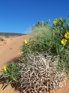
We hiked around on the dunes and then made our way to the very top of the large sand dune. Below is a picture of Jane and the kids as we were trekking up the spine of the main dune. All along the hike the dunes were covered with these beautiful yellow flowers (see picture below) that just added to the magic spell this park cast over us. As we were about to leave a number of dune buggies came roaring near the big dune (see picture below). Evidently, ATVing is a big activity in southern Utah and space is set-aside for their enjoyment. We were perched on top of the dune watching these guys zip around the smaller dune areas---it looked like a good way to get really dirty, but probably was also a lot of fun. Maybe we'll try this next time. Finally, after staying longer than I thought we would we did leave and headed back to Zion. The drive back to Zion (coming from the east) was labeled a scenic drive and from the Mt. Carmel junction into the park it was the most beautiful region I have ever driven through. Again, photographs can't capture the vistas we drove through, but I'll include a picture in the next post with a bird's eye view of the final switchbacks as the scenic road reaches the bottom of Zion Canyon. We finally got back to Springdale and had a fortifying but late (8 pm) dinner at the Driftwood Inn Lodge to prepare us for the next day's big challenge..........Angel's Landing.


Desert Southwest Vacation (Day 5) Part II

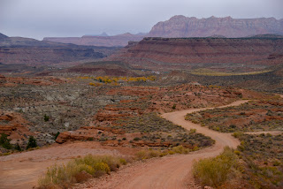
Day 5 (Wednesday, June 20th). After leaving Grafton the next stop was Pipe Spring National Monument. To get there I took a nine mile short-cut over an unimproved "dirt" road. Southern Utah is criss-crossed with a number of these dirt roads that are considered passable in dry conditons. It's wise to check with the locals that the roads are indeed passable--in this case the clerk at the Driftwood Lodge routinely had used this road and said it would PROBABLY be okay for our rental car. The couple mile climb up to the top of the mesa was a little unnerving as the road was badly eroded and that we were in the middle of nowhere with no one in sight if we got stuck (see picture above). That concern aside, the drive was very scenic and once we reached the mesa the road was in pretty good condition (see picture of the good portion of the road we traveled below right). Near the end of this road we passed this fence that had collected tumbleweeds which is where I stopped to take the picture at right. After reaching pavement again we headed southeast to Pipe Spring National Monument.


Pipe Spring provided a reliable water source in this generally dry and rather barren country. For early Mormon settlers the spring became the focal point for various buildings and eventually a small fort (named Winsor Castle after its constructor,

A.P. Winsor). The two-story fort, seen in the background in the picture on the left, was intended to protect the spring and neighbouring cattle grazing lands against Navajo Indian raids from the south; a threat that never materialised. The neighboring Paiute indians suffered due to cattle grazing the grasses that previously sustained them, however, it seems that the Paiutes and Mormons worked out their differences and achieved some measure of peacable coexistence.


Now, the fort, outbuildings, and various agricultural relics are preserved and serve as an interesting illustration of pioneer life. Because it is isolated geographically the Pipe Spring is not a popular tourist destination, however it is definitely worth a visit and can easily be completed in an hour or so including the tour of the fort. There are nice gardens, crops, along with buildings and exhibits. These include besides the fort, a blacksmith's shop, poultry and riding sheds, two ponds with resident geese, an orchard, old wagons, a corral and riding equipment. Other animals include Texas longhorn cattle, chickens and horses. Pipe Spring itself is covered by the fort; the water runs underground through pipes and across one room in an open trough before emerging to supply the ponds. The open trough was used for keeping food chilled (and the water was quitedchilly); of the food items made in the room with the trough was butter and cheese.


The tour guide indicated that there were about 10 main rooms on 2 levels, in 2 sections with doors and windows facing inwards to a central courtyard, all enclosed by a high wall. The fort was partially built into a hillside and the walls were thick to keep in the cool air. On our tour of the fort, the air inside was very comfortable. Although the defensive capabilities of Pipe Spring were never tested the guide pointed out that the small windows above the beds (in an upstairs bedroom) were originally designed to serve as gun ports. However, the fort was used primarily as a ranch and waystop for thirsty travelers and later as a private residence. The fort was designated a National Monument in 1923.


Afterward, we made our way to the north rim of the Grand Canyon. The north rim is supposedly less crowded and has better views than the south rim. The downside is the driving around needed to get to the overlooks. We just went to the Bright Angel area were the visitor center and lodge were located. We did a little hiking along the rim and a lot gazing. We had a nice day with good visibility and could see the trail to the south rim. To appreciate the Grand Canyon I think one needs to hike it rim to rim or take a 4-6 day ride down the Colarado river. Both are on our list of future vacations. Views of the Grand Canyon from Bright Angel Point are below.


July 02, 2007

Desert Southwest Vacation (Day 5) Part I

Day 5 (Wednesday, June 20th). Today we used Springdale as a springboard for all-day side-trip to the ghost town of Grafton, Pipe Spring National Monument, the north rim of the Grand Canyon and Coral Pink Sand Dunes State Park. This would prove to be a busy but richly rewarding day. To get to Grafton we had to backtrack to the town of Rockville (about a 5 minute drive west from Sprindale) and take a dirt road (see picture at left) that led through wilderness out to the town. The dirt road to Grafton was itself very scenic (although a little dusty).


The ghost town of Grafton (1863-1924) and Grafton cemetary (see pictures below) are located a few minutes drive west of Sprindale near the town of Rockville. Grafton was one of several settlements along the Virgin River colonized in the 1850s. In 1861, Mormon Church President Brigham Young called hundreds of families to relocate to southwestern Utah to help establish a Cotton Mission. The principle objective was to produce enough cotton to supply church members' needs and thereby end reliance upon eastern markets for that product. In the southern region's cruel environment, however, the Cotton Mission never really flourished. The early settlers of Grafton quickly learned that the Virgin River was generally untamable. Although they needed water for crops the farmlands around Grafton lay in very narrow strips along either side of the Virgin River and its tributaries and were highly susceptible to erosion from flooding. The Virgin River and its tributaries all ran high floods that obliterated the first colonizing attempt at Grafton. In addition to the unpredictable river, residents also experienced difficulties with Indians during the Black Hawk War (1865-68). An example of the "difficulties" was evidenced by several gravestones which noted the cause of death.....killed by indians (see Isabelle Hales gravemarker at bottom of post)! More recently Grafton was also hit hard by flooding in 1909. By 1920 Grafton's population had dwindled to three families, and by 1930 the river had completely won--it became a ghost town. The last resident moved away in 1935. Other headstones, with telling inscriptions, give some insight into the harsh life at that time, such as the three Berry brothers (and one wife), all killed by Indians on April 2nd 1866, or the five children of John and Charlotte Ballard, all of whom died young between 1865 and 1877, none living for more than 9 years. Although the ghosts of Grafton may have their own memories Grafton is largely remembered as the town where the famous "Rain Drops Falling On My Head" scene from "Butch Cassidy and Sundance Kid" western was filmed.


Desert Southwest Vacation (Day 4)

Day 4 (Tuesday, June 19th). We would stay the next two nights in Sprindale with an emphasis on exploring Zion Canyon National Park. One of big activities around much of southern Utah, and in Zion, is canyoneering which involves hiking along streambeds in narrow canyons called slot canyons. Today was our much anticipated canyoneering adventure, a hike up the North Fork of the Virgin River to a region called the Narrows. The Zion Narrows is a legendary hike, a must-do if you visit Zion. Since the hike is alongside and through the Virgin River, which carved this spectacular slot canyon, it's a great hike in summer; the temperature in the canyon is supposed to be approximately 10 degrees cooler and there is a lot of shade.


We began the day by renting 5.10 Canyoneer river shoes, neoprene socks and staffs from an outfitter conveniently located in Springdale and boarding the local shuttle to Zion. The hike to the Zion Narrows begins at the end of an easy one-mile Riverside Walk Trail at the Temple of Siniwava shuttle stop. We had an annoying shuttle bus driver, "Dan-Dan the driving man", who tried to amuse and educate us about the park as he SLOWLY drove us to the Temple of Siniwava stop. During the busy summer months the shuttle buses are the only means to get into the park. Although this was a little frustrating, I can only imagine how bad the drive would have been if all the visitors were allowed to drive into the park. Anyway, we eventually reached the Temple of Siniwava shuttle stop and hike the easy one mile paved Riverside Walk Trail. At the end of the trail we plunged into the Virgin River and started hiking upsteam. We hiked in ankle to knee-deep water navigating to dry, rocky patches along the shore where possible. See picture of Elroy hiking upriver at right. At the beginning the river channel was wide, the river bottom consisted of rounded rocks that were faily easy to walk over, especially equipped with canyoneering shoes and a sturdy staff for extra support. Although we saw some people hike upstream in bare feet or tennis shoes, I think the $17 rental fee for the canyoneering shoes and staff was money well-spent.


Less than half-a-mile from the Temple of Sinawava, we passed Mystery Falls, a beautiful spot where water rolls down the sandstone walls from the canyon above. Approximately two miles upstream the walls of the main canyon close-in, forming the narowest section of the canyon. This section is called the Narrows or Wall Street where the Virgin river is forced into a spectacular gorge, as narrow as 20 feet and as deep as 2,000 feet. See picture of Jane and kids at right. In the Narrows we were hiking in mostly shade, and in deeper water, with occasional narrow shafts of light penetrating the canyon opening to the water below. In some places the water ran deeper and swifter as the river was forced into this narrowed canyon space. There are ample warnings to not go into the slot canyons if there is any chance of flash flooding--I can see why. This being the summertime, there was zero chance of rain and there were a lot of hikers at the beginning but fewer the farther upstream we hiked. It was spectacular and almost impossible to photograph the scale of the canyon walls in the Narrows.


We hiked a side canyon of the Narrows, the Orderville Canyon. Orderville Canyon has much less flowing water, but there are many obstacles that involved a bit of rock-scrambling. The picture at left was a particularly nice fern-covered section of the canyon. Roughly half-a-mile up Orderville Canyon, we reached a small waterfall formation (Veiled Falls) where the National Park Service has placed a sign that prohibits further travel upstream. In all we spent 8 hours hiking--the most time we've ever spent hiking. I had to really take my time on the trek back to the River Walk Trail, my legs were tired and stumbled a bit. We stopped a few times to eat, drink and to refocus on getting back without getting hurt or wet. We were really tired when we finished and our feet, especially Jane' feet, were sodden and sore. We were happy when we finally got to take the wet shoes and socks off and rest poolside back at the hotel.